2023 aerial control program - Environment, Planning and Sustainable Development Directorate - Environment

2023 aerial control program

ACT Parks and Conservation Service is managing the 2023 aerial control program to remove pest species from key conservation areas periodically throughout the year. The public will be notified prior to and during any control programs and extensive safety precautions will be in place during the program, such as buffer zones, signage and sweeps prior to all operations. Community members should not be alarmed by aircraft operating at the impacted areas.

For the safety of visitors, public areas are closed during aerial control operations. Details of reserve closures are provided below.

SiteClosure period
Sherwood Special Purpose Reserve 16 - 22 September
Swamp Creek Nature Reserve 16 - 22 September
Stony Creek Nature Reserve 16 - 22 September
Bullen Range Nature Reserve 16 - 26 September
Gigerline Nature Reserve 16 - 26 September
Rob Roy Nature Reserve 16 - 26 September
Tidbinbilla Nature Reserve 19 - 20 September

For more information on the vertebrate pest management, visit the Vertebrate pests webpage.

A map of the Murrumbidgee River Corridor showing Sherwood Special Purpose Reserve and part of Uriarra Forest closed. Blue Range Recreation Area remains open.
A map of the Murrumbidgee River Corridor showing Swamp Creek Nature Reserve closed. Uriarra Crossing Recreation Area and Swamp Creek Recreation Area remain open.
A map of the Murrumbidgee River Corridor showing Stony Creek Nature Reserve and Hyles Forest north of Brindabella Road closed. Casuarina Sands and Cotter Recreation Area remain open.
A map of the Murrumbidgee River Corridor showing Bullen Range Nature Reserve, Miowera Forest and Pierces Creek Forest east of Paddy’s River Road closed. Kambah Pool Recreation Area remains open.
A map of the Murrumbidgee River Corridor showing Gigerline Nature Reserve and Ingledene Forest east of Smiths Road closed. Angle Crossing Recreation Area and Tharwa Sandwash remain open.
A map of Tidbinbilla Nature Reserve showing Pierces Creek Forest closed south of Flint Road. Woods Reserve remains open.

For the safety of visitors, public areas are closed during aerial control operations. Details of reserve closures are provided in the table below.

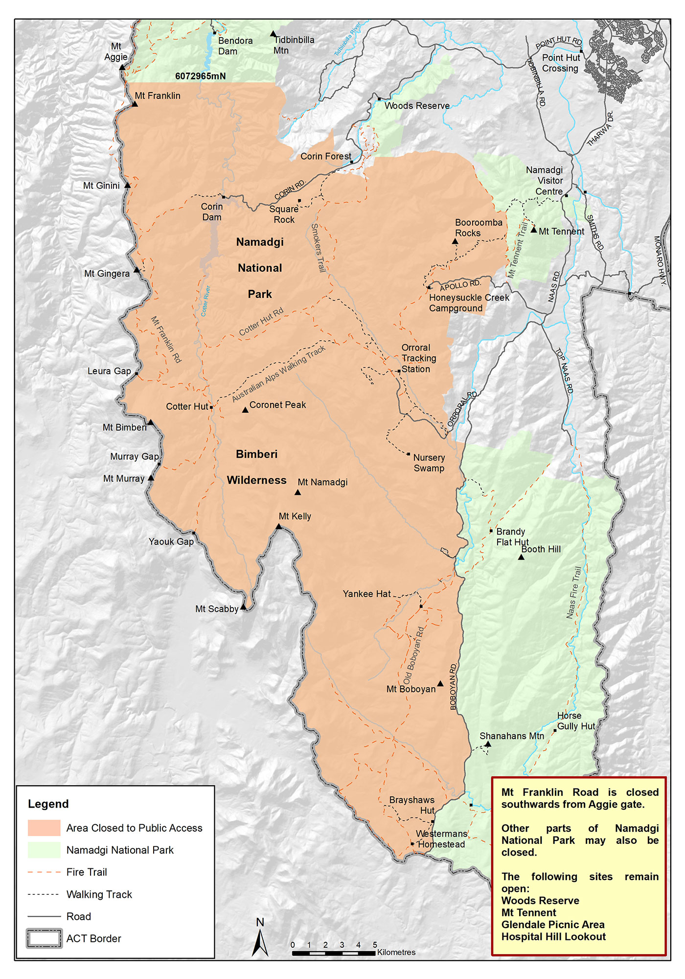
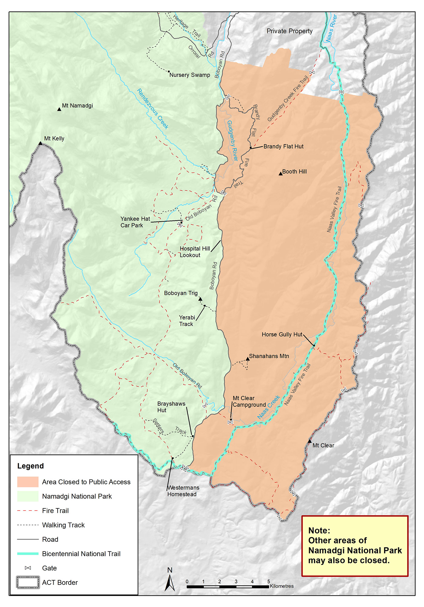
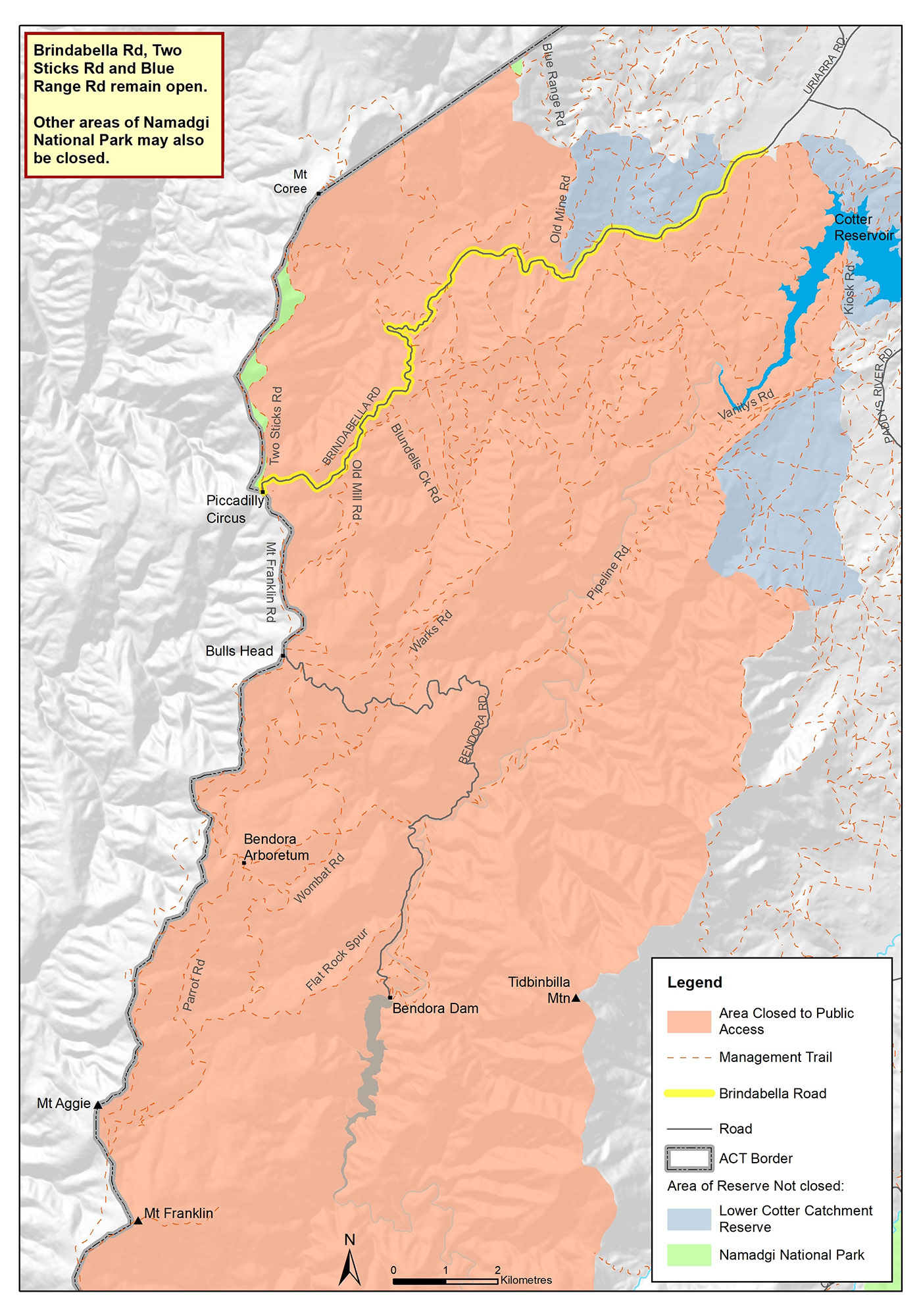
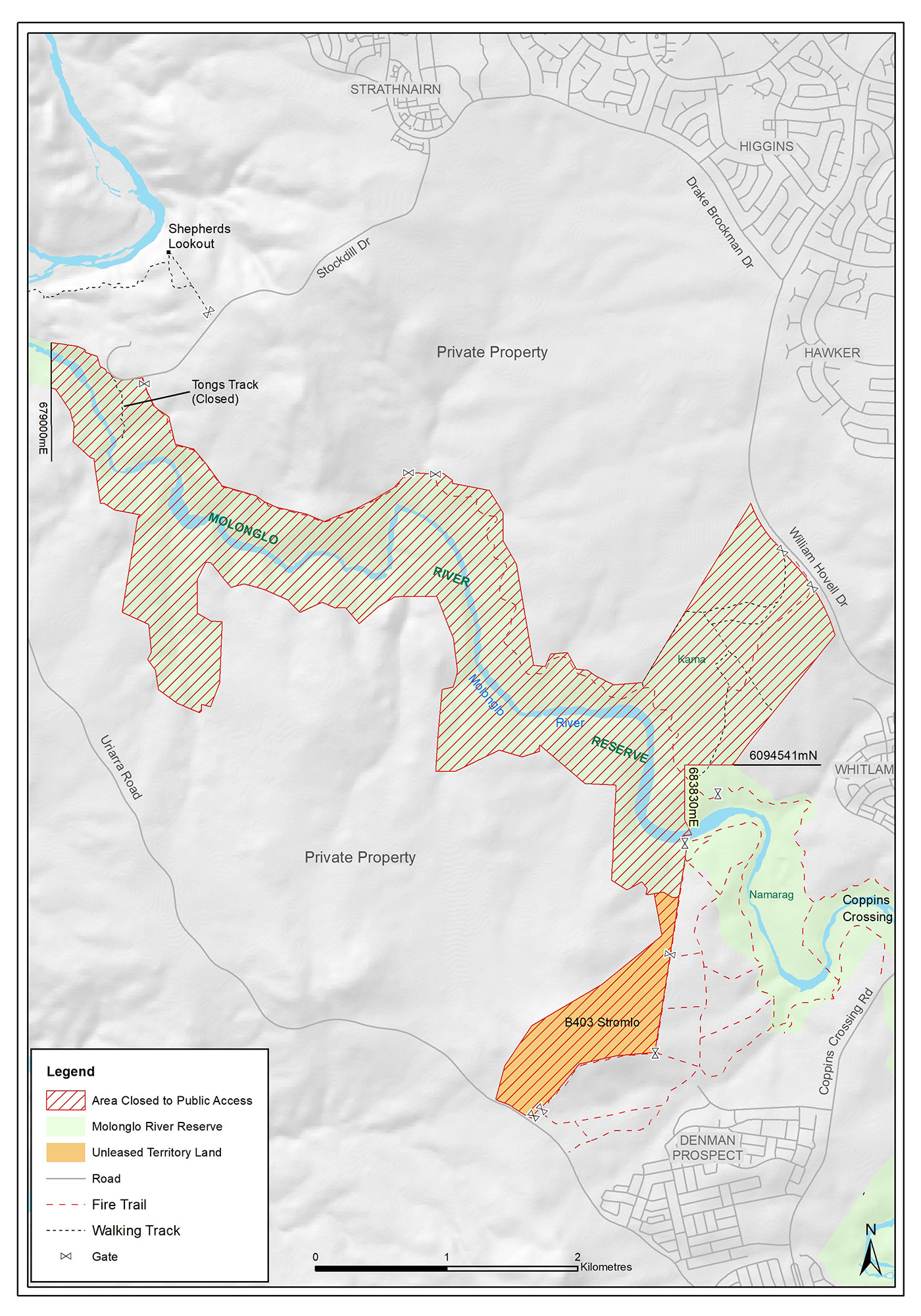
In May - June 2023, the following areas were closed to enable the aerial control program to be undertaken.

Site Closure period
Namadgi National Park Naas 15 - 19 May 2023
Namadgi National Park West 18 - 26 May 2023
Namadgi National Park North 22 - 26 May 2023
Lower Cotter Catchment 22 - 26 May 2023
Molonglo River Corridor 29 May - 2 June 2023
Googong Foreshore 29 May - 2 June 2023

For more information on the aerial control program, visit the Vertebrate pests webpage.

A map of Namadgi National Park showing that all areas, including walking tracks, fire trails, picnic areas, and camping grounds, west of Boboyan Road are closed except for Gibraltar Falls, Mt Tennent, Woods Reserve, Woods Reserve to Gibraltar Falls Track.
A map of part of Namadgi National Park showing areas east of Boboyan Road that are closed, including part of the Naas Valley Fire Trail, Bicentennial National Trail, Gudgenby Creek Fire Trail and Brandy Flat Fire Trail, Shanahans Mountain, Mount Clear Campground, Horse Gully Hut and Brandy Flat Hut.
A map of part of the Lower Cotter Catchment and Northern Namadgi National Park including walking tracks, fire trails, and picnic areas that are closed. The Lower Cotter Catchment closure follows the western edge of Kiosk Road, Water Tank Rd, Concrete Crossing Rd, Vanity’s Rd and Razorback trail. The Northern Namadgi closure follows the Park Boundary except on the eastern boundary where the closure follows the Eastern edge of Two Sticks Rd. Brindabella Road and Two Sticks Road remain open.
A map of part of the Lower Cotter Catchment and Northern Namadgi National Park including walking tracks, fire trails, and picnic areas that are closed. The Lower Cotter Catchment closure follows the western edge of Kiosk Road, Water Tank Rd, Concrete Crossing Rd, Vanity's Rd and Razorback trail. The Northern Namadgi closure follows the Park Boundary except on the eastern boundary where the closure follows the Eastern edge of Two Sticks Rd. Brindabella Road and Two Sticks Road remain open.
A map of Molonglo River Reserve and adjacent unleased territory land showing that all areas area including walking tracks and recreation areas are closed.